Finally, high-quality map production software that works. MAPublisher cartography software seamlessly integrates over 40 GIS tools into the Adobe Illustrator environment to help you create maps the way you want, how you want. Import the most widely used GIS data formats, including those from ESRI, MapInfo, MicroStation, AutoCAD, Google and the U.S. Government.
All GIS data attributes and geographic parameters are maintained, are fully accessible and editable. Export data in a wide variety of standard GIS formats and export documents to Geospatial PDF. Cartography is now faster, easier and better than it has ever been. When used together with Geographic Imager for Adobe Photoshop, they form the perfect vector/raster mapping package for the Adobe Creative Suite.
Export Adobe Illustrator documents with GIS data to interactive Flash maps, complete with callout bubbles, rollovers, layer control, pan and zoom controls, and with all the underlying GIS attributes intact. Export Flash maps without any additional coding or software requirements and embed them to any Web page
In MAPublisher create Adobe Acrobat PDF files containing coordinate system and attribute data from any MAPublisher document. Find locations, measure distances, perimeters and areas, add locations markers and more.
Directly import feature classes from ESRI Personal geodatabase (.mdb), File geodatabase (.gdf ) and ArcSDE servers. Use SQL queries and spatial filters to refine import. Requires ESRI software and a valid license installed and is only available on Windows.
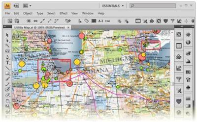
MAPublisher panels seamlessly integrate into the user interface and can be resized, moved, and docked just like native Adobe Illustrator panels.
Crop map documents only to the area of interest. Easily remove unwanted data while preserving attributes and styles. Perfect for creating inset maps.
The ability to place points onto a map is a fundamental part of cartography. Points can represent the locations of towns and cities, stores, airports, train stations and more. Instantly Description centroids and lat/long points onto any projected map in projected units, decimal degrees, or Degrees Minutes Seconds.
Import data from major GIS applications such as ArcGIS, MapInfo, MicroStation, Google and other GIS sources with all attributes and georeferencing intact and fully editable. Make vector and database edits, data edits, additions and save your changes to a variety of GIS data formats.
MAPublisher quickly and easily styles points, lines, areas and text. Specify rules in MAP Stylesheets to apply preset or custom symbols, graphic styles and character styles to artwork based on exisiting map attributes.
والثانية
خطا شائع عند كثير من الناس في قراءة حفص بل في كل القراءات العشر
تسكين الباء في كلمة السبع في قوله تعالى ( وما اكل السبع ) سورة المائدة الاية 3
والصحيح ضمها لان المراد بها هنا حيوان السيع بخلاف السبع المراد بها العدد سبعة فان الباء تسكن كما في سورة المؤمنون الاية 86
- قل من رب السموات السبع ورب العرش العظيم - ولا تنسى قراءاة كتاب اسمه الاخطاء الشائعة في قراءة حفص وهذا رابطه لتحميله https://archive.org/download/3245834...83568/hafs.pdf
واسمع اليها في تلاوة عندليب الاسكندرية الخاشع الشيخ شعبان محمود عبد الله السورة رقم 5 المائدة ورقم 23 المؤمنون
حيث يقف الشيخ على كلمة السبع في سورة المائدة لتوضيح ضم الباء http://archive.org/details/sha3baan-mahmood-quran
وحين تفتح لك الصفحة اقرا فيها كيفية الحصول على كل مصاحف صوت القاهرةبجودة رهيبة لا تصدق سي دي اوديو معدل الجودة 1411 ك ب
وايضا بجودة رهيبة ام بي ثري معدل الجودة 128 كيلو بايت
ايضا تجد في نفس الصفحة
رابط ل ملف مضغوط zip فيه روابط ل 696 مصحف مقسمين الى روابط تورنت ومباشرة وجودة فلاك مع الشرح كيف تكفر عن ذنوبك وتكسب ملايين الحسنات عن طريق التورنت
مع برنامج تورنت سريع وشرح كيفية عمله
مع هدايا اخرى ومفاجات
هذه المنتديات لا تتبع أي جماعة ولا حزب ولا تنظيم ولا جمعية ولا تمثل أحدا
هي لكل مسلمة محبة لدينها وأمتها
وهي على مذهب أهل السنة والجماعة
ولن نقبل اي موضوع يثير الفتنة أو يخالف الشريعة
وكل رأي فيها يعبر عن وجهة نظر صاحبه فقط
دون تحمل إدارة المنتدى أي مسؤلية تجاه مشاركات الأعضاء ،
غير أنَّا نسعى جاهدين إلى تصفية المنشور وجعله منضبطاً بميزان الشرع المطهر


 العرض العادي


